“AGI32 22.1.0.28 update 2024 Lighting Analysts – Illuminating Engineering Software” has been added to your cart. View cart
Sale!
Stringer Topo for Civil 3D 2026 Perpetual License
Rp5,000,000.00Original price was: Rp5,000,000.00.Rp2,605,600.00Current price is: Rp2,605,600.00.
Indonesian rupiah (Rp) - IDR
United States dollar ($) - USD
Indonesian rupiah (Rp) - IDR
Euro (€) - EUR
Total Sold0
✅Full Version
✅Supports Windows 7/8/8.1/10/11
✅64 bits compatibility ✅
✅Comes with all necessary files to Install & Activate
✅Permanent activation
✅Install guide is included
✅It can be installed on as many computers as you want
✅One-time payment!
✅ If you agree to buy, you have agreed to the terms and conditions of no refunds if the reason is as described Terms and Conditions
✅ License Unlimited, Can be installed on many PCs
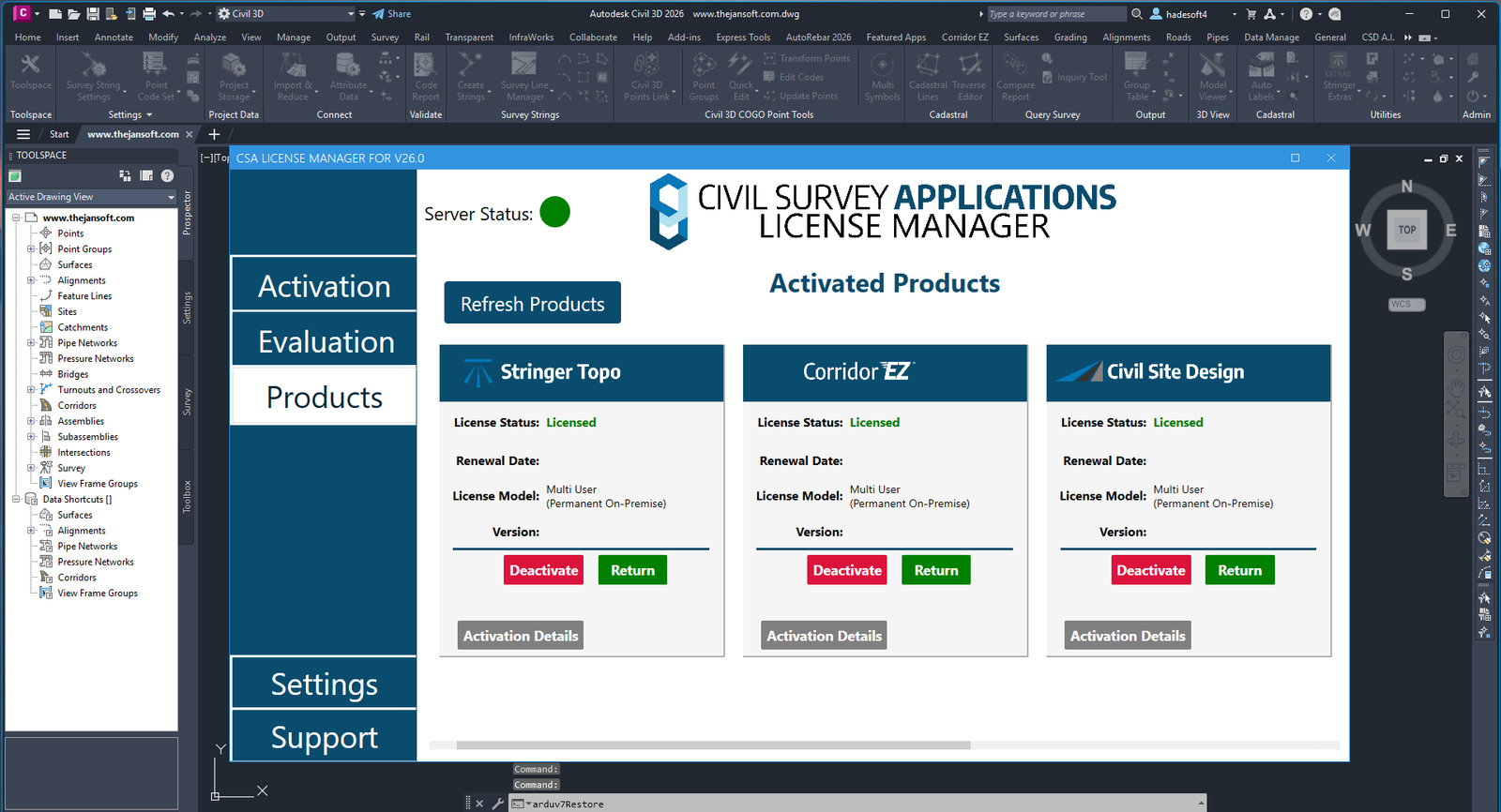
✅ Stringer Topo for Civil 3D 2026 v.26.02.20
✅ Active Period: Lifetime (can reinstall)
✅ Support: Windows 10, 11
✅ Update Application: No
✅ Install Instructions: Available (video/text)
✅ It should be noted, buying = understanding product use
Note:
Stringer Topo has been developed to streamline the reduction and presentation of survey observations inside your drawing, whether you’re using AutoCAD, AutoCAD Civil 3D or BricsCAD. Developed by surveyors with over 20 years experience in the industry, Stringer Topo focuses on maximizing your efficiency in adding and editing breaklines, automating linework display, adding and editing point data, creating surfaces and table outputs directly in the drawing.
Stringer Topo delivers fast, easy to use survey tools for creating topographical surveys in your drawing, ready for final documentation and plotting. Associated functionality includes survey quality (comparison) reporting, point export, import/export to numerous formats, traverse editing and drafting for cadastral plans.
Extensive COGO Point Functionality
For Civil 3D users, Stringer Topo enables advanced editing with dynamic links to other objects as well as the ability to store and report extended property data such as alignment references
For AutoCAD and BricsCAD users, harness the power of dynamic blocks and attributed text to fully customise the display of your COGO points, automatically displayed how you like based on your point descriptions
Quickly edit point coordinates using Helmert or Affine transformations
Reduction of Raw Survey Observation Data
Provides you with the ability to convert multiple raw observation files into a single editing interface with graphical feedback as survey edits are applied. Create coordinated points from the survey data and maintain a link between survey and output points.
Automated Survey Linework and Breaklines
Works directly on COGO points and surfaces in the drawing to automate the breakline creation process and enable immediate updating of surfaces as points are edited
Makes it quick and easy to add, edit and remove breaklines and survey linework directly inside the drawing. With a wide collection of point and string editing tools you can quickly correct any pickup errors and get to the finished product.
Survey Tools and Outputs
Create highly customisable legend and other reporting tables in your drawing at the click of a button
Detailed comparison reporting tools for QA reporting: compare points, surfaces, alignments, lines and polylines
Draw cadastral lines, label area polylines and apply traverse adjustments
Reviews
There are no reviews yet
Only logged in customers who have purchased this product may leave a review.
 Winmostar V11.10.0 Professional Edition Elite License
1 × Rp350,000.00
Winmostar V11.10.0 Professional Edition Elite License
1 × Rp350,000.00  NVIVO 1.6.1 Lifetime Activation
1 × Rp160,000.00
NVIVO 1.6.1 Lifetime Activation
1 × Rp160,000.00  PhotometricToolbox 2.14.0.23 Lifetime Activation
1 × Rp275,000.00
PhotometricToolbox 2.14.0.23 Lifetime Activation
1 × Rp275,000.00  TextAutoReply 1 Years
1 × Rp85,000.00
TextAutoReply 1 Years
1 × Rp85,000.00  AGI32 22.1.0.28 update 2024 Lighting Analysts - Illuminating Engineering Software
1 × Rp450,000.00
AGI32 22.1.0.28 update 2024 Lighting Analysts - Illuminating Engineering Software
1 × Rp450,000.00 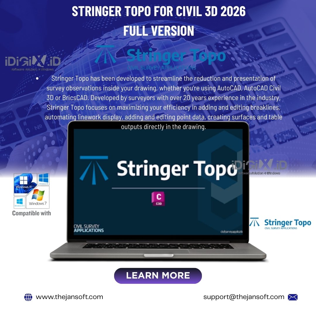


Reviews
There are no reviews yet